11 km photo showing Earth's curvature
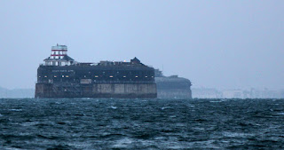
This is a photo taken from Puckpool, Isle of Wight, of the two main Solent forts. Behind the forts is the seafront at Hayling Island, just about exactly 11 km away. The hotel buildings you can see here are up a sloping beach, then a grass area, and their ground floors are at least 15 feet above sea level. Look on Google street view. Or if you don't trust that, go there and look. Unless they've just suffered some severe subsidence in Hampshire, the Earth is curved.